73 Miles / 6800 Feet of Climbing
Mixed-surface madness! This ride takes you on a challenging journey across a wide range of landscapes (flats, rollers, stingers, climbs, descents) on roads of all kinds (asphalt, chipseal, gravel, dirt, rock) through a crazy mix of settings (woods, farmland, civilization, banjo-land). It's like a dozen different bike rides rolled into one all-encompassing awesome experience!
Potential Route Modifications: You can cut out a couple of miles of gravel and some steep hills by skipping Overlook Trail and following Lowes Gap Road down to Shut In Gap Road and picking up the route a little over a mile and a half down the road. For more variations on this route, check out Monkey Town Lite and Monkey Town Double Stout.
And now for something completely different! Our goal in creating this route was to do more than provide a big challenge. (In our neck of the woods, that's not too hard to do!) What we wanted was something unique and different from the clearly defined road, gravel & MTB rides. We wanted a ride that showcased the incredible cycling diversity of rural Tennessee. While it is certainly a tough route, it's more about the variety of experiences you'll have along the way. It's a crazy mix that adds up to one truly epic bike ride! Here's the breakdown:
1. WARM-UP: The first six and a half miles after leaving Monkey Town Brewing Company will take you out of downtown Dayton on rolling roads past some nice large-lot estates and small farms before reaching the base of the climb up Walden Ridge.
2. EVENSVILLE CLIMB: This is the first of two monster climbs on the route. It's steep (plenty of double-digit pitches) and long (three and a half miles). It also has a number of false summits before you reach the top of Walden Ridge. Don't let up until you see the cell tower!
3. LIBERTY HILL ROAD: After battling the climb, you'll be able to recover on a relatively flat stretch that lasts almost six miles. We say "relatively" because it has a rise in the middle that you will definitely notice.
4. CYRUS DANIELS ROAD: After crossing Summer City Road, the road will change names and narrow considerably. This is a great little section that lasts about two and a half miles and feels more like a driveway than a road. It starts off as rough asphalt and then turns into gravel the rest of the way.
5. PORCH ROCK ROAD: The gravel section ends at Porch Rock Road, where you'll turn left and ride along the escarpment overlooking Sequatchie Valley for a mile and a half. Unfortunately, the wooded nature of this road obscures the view off the edge, but every now and then you'll get a window into how high you are. (Also keep an eye out for the green dinosaur!)
6. HWY 30 DESCENT: This is definitely a highlight, as you bomb down Walden Ridge into Sequatchie Valley on smooth pavement and smooth curves for over four miles! The descent has the perfect grade that's steep enough to coast if you want to take it easy but not too steep that you can't pedal through the curves if you want to push your speed.
7. SEQUATCHIE VALLEY: After bottoming out, you'll enjoy fourteen and a half miles of gorgeous farmland scenery in the quiet north end of Sequatchie Valley. As a road ride, it doesn't get any better than this, with sweeping views and peaceful rollers. Consider this section the calm before the storm.
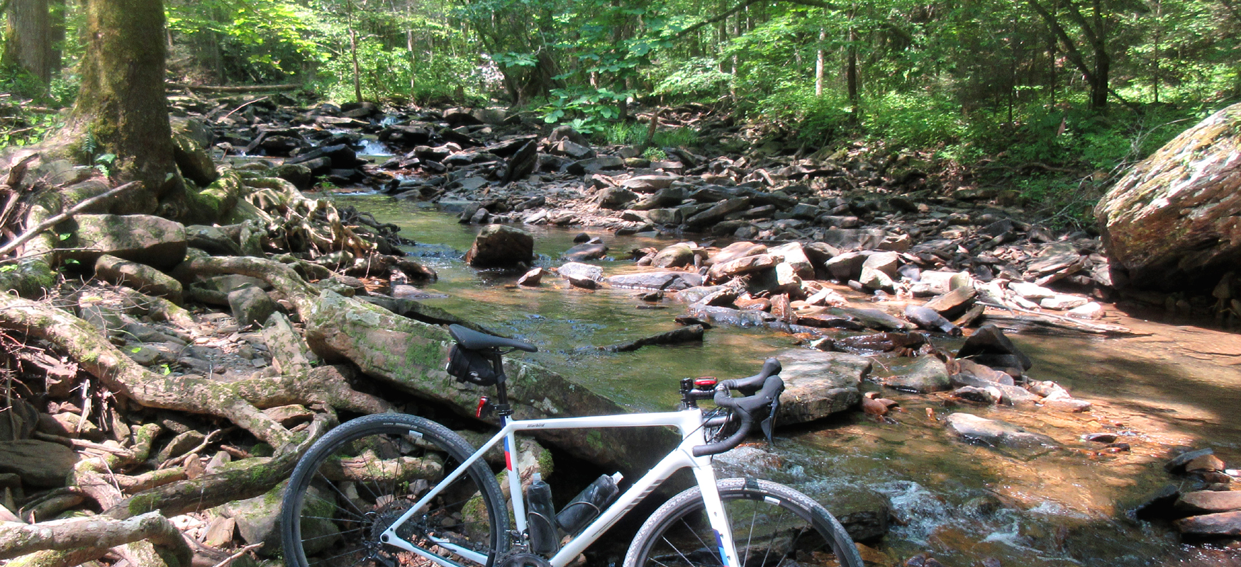
8. LOWES GAP: This is the second monster climb of the day, and though shorter than the first one (only two miles), it is arguably more challenging since it's unpaved and super steep - up to 20% in parts! It's a gorgeous climb with plenty of tree cover, ferns and big rock faces, plus a cascading stream to keep you company. (You might also spot a boat in the woods along the way!)
9. OVERLOOK TRAIL: Lowe's Gap returns to pavement towards the end of the climb and for a brief moment you'll think you're home free. Then you'll turn left onto Overlook Trail. This gravel road starts off with a mile-and-a-half climb at a relatively manageable grade. Then it heads downhill before launching you onto another climb. This second climb is shorter, only a half-mile total, but it has a pair of ramps that will test your legs, with one of the ramps topping out at 32%!
10. HOLLOWAY TRAIL: The payoff for all the work on Overlook Trail is almost two miles of unpaved downhill on Holloway Trail. This is a fun road with a few panoramic views and a cool lake towards the bottom. Watch out for the curves though, as some of them tend to be pretty loose. Also watch out for the llamas!
11. SHUT IN GAP ROAD: When you end up on a road named "Shut In Gap" you know you're in the boonies, especially when your first landmark is the aptly named "Bridge to Nowhere." (It will be on your left shortly after you turn onto this road.) Despite its name, the road is actually well-paved and may have an occasional car. So stay to the right and enjoy some fun curves on a section that will feel refreshingly fast after all that off-road labor.
12. WALDEN MTN/PINE CREEK: After channeling your inner roadie for a little over two miles on Shut In Gap Road, you'll turn onto what we think is the best unpaved section of the ride. The next seven and a half miles will have you rolling deep in the woods with a never-ending series of ups & downs in a beautiful setting that includes a couple of creek crossings. (Unless it's been flooding, the low bridges should be enough to keep you dry and mounted on the bike.) Watch your lines carefully on this section as the road is more dirt, sand & rocks than gravel. Fun stuff in the middle of nowhere!
13. WASH PELFREY: This long stretch of dirt ends at Wash Pelfrey Road which is paved but still a far cry from civilization. It's a great road with a short curvy descent down to Piney Creek before a relatively flat stretch back to the top of the Evensville climb. In total, Wash Pelfrey is not quite five miles, but given the state of your legs at this point, it will seem like twice that as you try to make your way back to the landmark cell tower!
14. EVENSVILLE DESCENT: Once you reach the cell tower, you will officially be on the home stretch with an amazing descent in front of you. Watch the curves and keep your speed under control, but sneak a peek at the views every now and then. On a clear day you can see all the way to the Southern Blue Ridge Mountains!
15. COOL-DOWN: After three and a half miles of exhilarating downhill, you'll bottom out and roll your way back another six and a half miles to the brewery, where you'll find plenty of cold beer and great food!