48 Miles / 1600 Feet of Climbing
A scenic survey of the lower valley with fun, historic and tasty stops along the way!
Potential Route Modifications: This route can be shortened to 28 miles by turning left on Ketner Mill Road (rather than turning right) after visiting the old mill. Head west on Ketner Mill Road until you reach Valley View Highway and then continue the route heading south from there. You can also reduce the route by another 4 miles by skipping the ride up Coppinger Cove Road to see Sequatchie Cove Farm. This route can also be ridden by starting in Powells Crossroads (park at Crossroads Park).
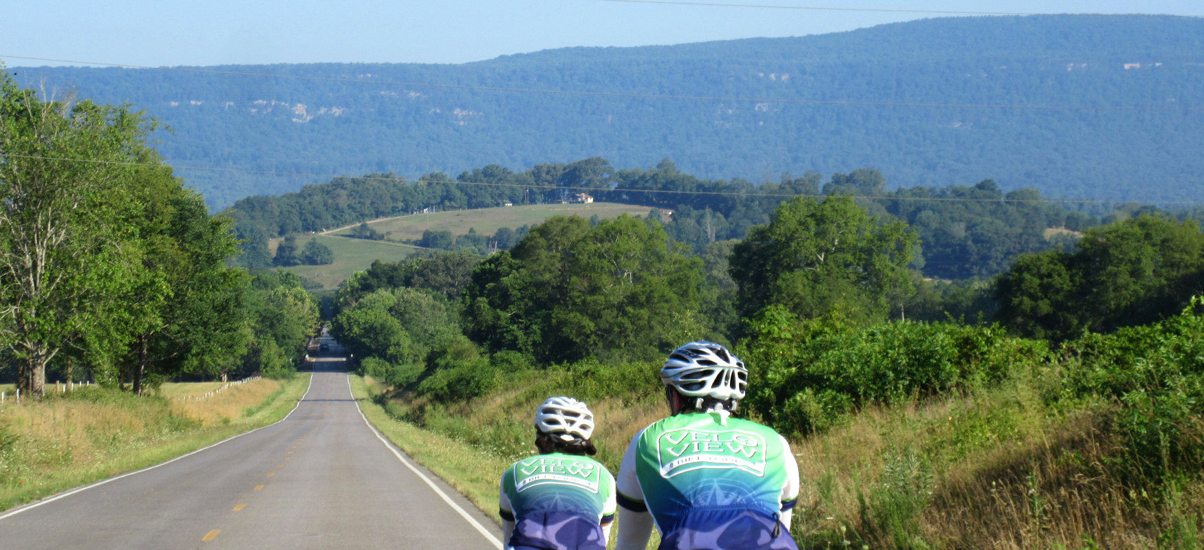
This ride has it all - history, agriculture, small town Americana, ice cream! - and it features some fantastic roads with beautiful views of the valley from both sides and down the middle!
The route starts in Jasper on the southern end of Sequatchie Valley. Jasper is named for William Jasper, a South Carolina war hero from the American Revolution, and was founded in 1820 as the Marion County seat on land granted by Betsy Pack, the daughter of a Cherokee chief. (You’ll ride a short portion of Betsy Pack Drive on this route.) The County Courthouse in the main square off of Main Street was built in 1925, and the building that now serves as the Jasper City Hall (just southeast of the courthouse) is the old train depot dating back to the 1920’s.
We recommend parking at Las Margaritas, a Mexican restaurant off of Main Street, which gives you easy access to the quiet neighborhood streets of Jasper to start the ride, and also gives you easy access to great food and drinks after the ride! You might also consider a post-ride meal at Cafe 41 and the Snack Shack.
If you start your ride before Las Margaritas is open, there is an Exxon station across the street that has a restroom. (As is always the case, making a small purchase in exchange for use of the restroom is good cycling etiquette.)
After leaving Las Margaritas, you’ll roll through neighborhood streets eventually working your way over to Betsy Pack Drive, which becomes Valley View Highway after you pass through the big four-way stop at Highway 41. After a couple of miles on Valley View Highway, you’ll turn right onto Mel Dixon Lane at the Pine Grove Cemetery.
Mel Dixon Lane will take you to Highway 28, which is the primary north-south roadway that runs down the middle of the Sequatchie Valley. Anyone wanting to get anywhere in a hurry will use this roadway, which thankfully takes a lot of traffic off of the other north-south roads in the Valley. After crossing Highway 28, you’ll take a left onto Francis Spring Road. This is a fun road with a mix of shaded tree-covered sections and open farm scenery. Francis Spring Road will also give your legs a good warm-up with a series of punchy rollers!
At roughly Mile 8.5, you’ll take a right onto Caroline Chapel Road. Pay attention to your odometer, because this road does not have a street sign. Half a mile later, you’ll turn right onto Inman Road which runs straight over to Griffith Highway where you’ll take a left. Griffith Highway is the primary north-south roadway on the east side of the valley. It’s not as heavily traveled as Highway 28 which runs down the center of the valley, but you’ll still want to look for vehicles along this stretch of road.
A few miles later, just past Mile 11, you’ll take a left onto Ketner Mill Lane. Again, this road is unmarked, so you’ll need to keep an eye on your odometer. (Also, look for the Oak Grove Cumberland Presbyterian Church on your right. In addition to alerting you to the upcoming turn, the church, which was founded in 1888, is a notable landmark all on its own with its classic country church style.) Once on Ketner Mill Lane, keep an eye out for potholes. It's a beautiful little tree-lined road, but it does have some rough pavement!
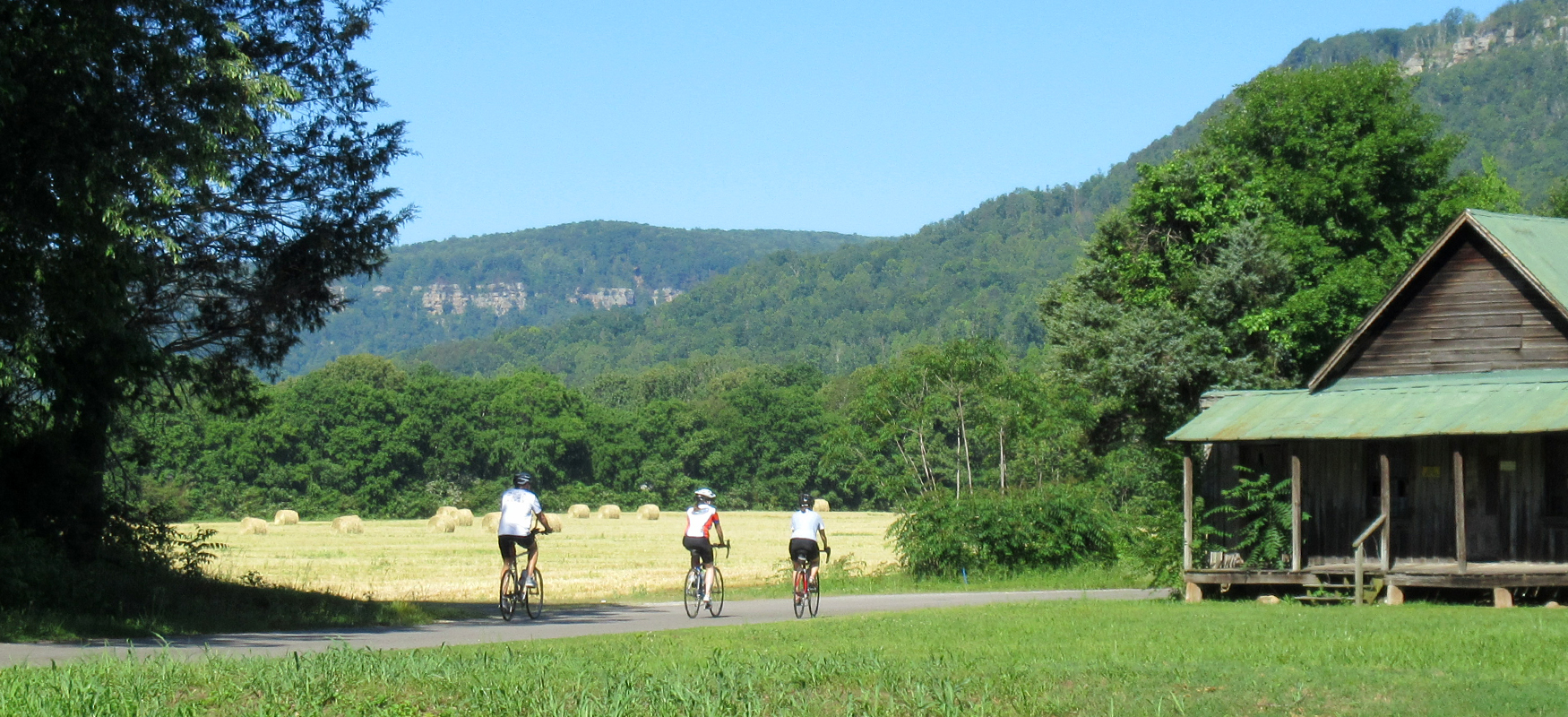
As the name suggests, Ketner Mill Lane will take you to Ketner’s Mill, which dates back to the 1880’s and is listed on the National Register of Historic Places. The mill was originally used for grinding grain and sawing lumber. While the sawmill ceased operations in 1955, the gristmill continued until 1992. Now the mill only operates once a year in October at the annual Ketner’s Mill Country Arts Fair, which started in 1977. The old building and dam give a glimpse into the history of Sequatchie Valley and are definitely worth a photo stop!
Continuing along Ketner Mill Lane will take you to Ketner Mill Road, where you’ll take a right and head back over to Griffith Highway. A left turn on Griffith Highway will have you heading north towards the little community of Powells Crossroads. As you roll towards the heart of Powells crossroads (which is simply a signalized intersection), look to the right (around Mile 16) for Crossroads Park. There’s a bathroom by the ballfields.
If you need something more than just a bathroom break, continue to the traffic light. From here, you have the choice of going to the right for a convenience store (Crossroads Market) or turning left for a proper lunch at SueBob’s Diner.
After the pit stop in Powells Crossroads continue north on Griffith Highway, which changes names to the Alvin C York Highway (Highway 283). You may feel a little traffic as you move through Powells Crossroads, but it will lighten up the farther north you go.
If you opted not to stop in Powells Crossroads, you'll have another opportunity for a break at Saynes Country Store, roughly 3 miles after passing through the traffic light. This well-stocked convenience store also has a photo-worthy view!
Just before you reach Mile 23, take a left on Condra Switch Road. This is a fun road with some great views. It also has a tough climb at the beginning, so be sure to gear down for it and enjoy the sweeping view at the top!
Condra Switch Road will cross over the Sequatchie River (look for kayaks and canoes in the summer) and eventually run into Highway 28. Go straight across the highway and then turn left when it “T’s” into Old Dunlap Road. About five miles later, Old Dunlap Road will become Main Street as you enter the town of Whitwell. Whitwell has a number of good rest stop opportunities, including the Whitwell Dairy Bar. Stopping for an ice cream is highly recommended!
And if you're interested in the history of the area, check out the Marion County Coal Miner's Museum, which does a great job of telling the story of the area's coal mining past.
As you continue south through Whitwell, be sure to stop at the Children’s Holocaust Memorial located on the grounds of the Whitwell Middle School. The centerpiece of this unique exhibit is an actual 1917 German railroad car, one of the last surviving “death cars” used to transport prisoners to concentration camps during the Holocaust. The railcar contains 11 million paperclips, each symbolizing a victim of the Holocaust.
The memorial evolved from a simple class project in 1998, in which Whitwell middle school students asked that they be allowed to collect something symbolic to help grasp the enormity of 11 million deaths. They chose the paperclip, as it was invented by a Norwegian Jew, and it was used as a symbol of protest by the Norwegian people during the Nazi occupation of their country.
Rather than simply purchase paperclips, the students wrote to famous people asking for paperclips and invited others to donate as well, each with a letter explaining why they were contributing to the project. Over time, the students collected 30 million paperclips from around the world!
When a pair of German White House correspondents heard about the project, they purchased the railcar and arranged for it to be shipped to Whitwell. The Memorial and the story behind it are truly inspirational and well worth the stop.
Leaving the Memorial, you’ll head south on Valley View Highway another five miles before turning right onto Coppinger Cove Road. (This road does not have a street sign, but there is a sign for Coppinger Cove Baptist Church at the intersection.) As you make your way along Coppinger Cove Road, you’ll see a sign for Trials Training Center. Although the Center caters to another type of biker (“trials” refers to a technical style of motorbike riding, essentially riding through an obstacle course), they do have cabins and camping if you’re in need of overnight accommodations. They also occasionally have downhill mountain bike races for highly skilled cyclists looking for a technical challenge!
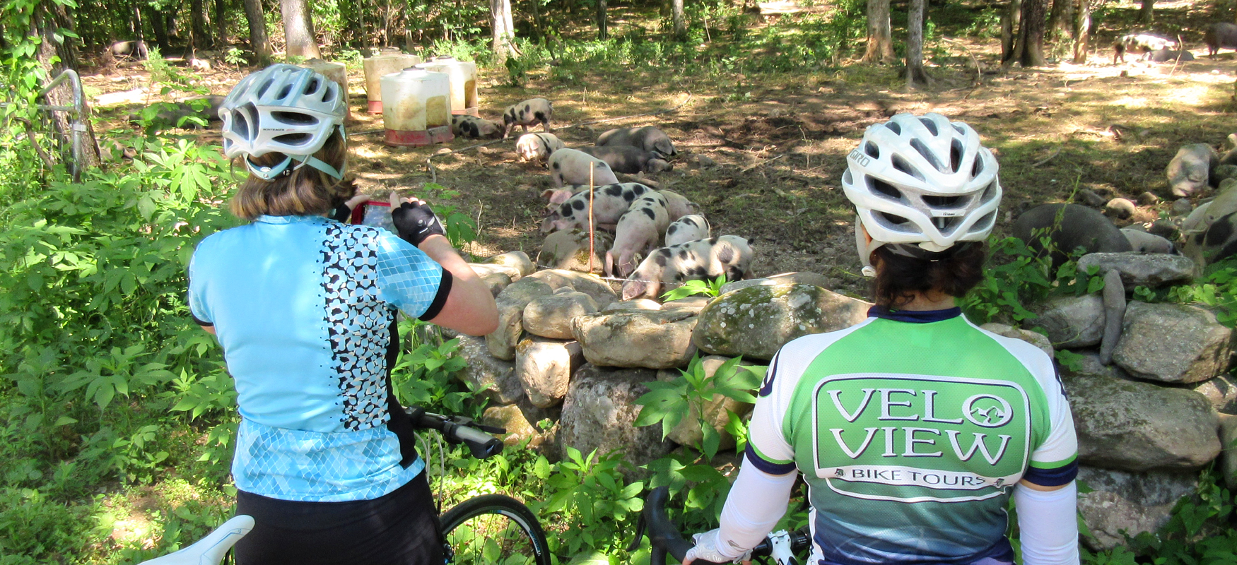
Continuing along Coppinger Cove Road will eventually run you straight into Sequatchie Cove Farm. You’ll know you’re there because the road will narrow and on your right you’ll see solar panels and the Sequatchie Cove Creamery. Take the driveway to your left and check out the Trading Post store. This is where you’ll find fresh vegetables, choice cuts of meat, and some of the best cheese you’ll ever taste! (Being on two wheels, you may need to plan a return trip in a car to load up!) There’s also a bathroom near the Trading Post.
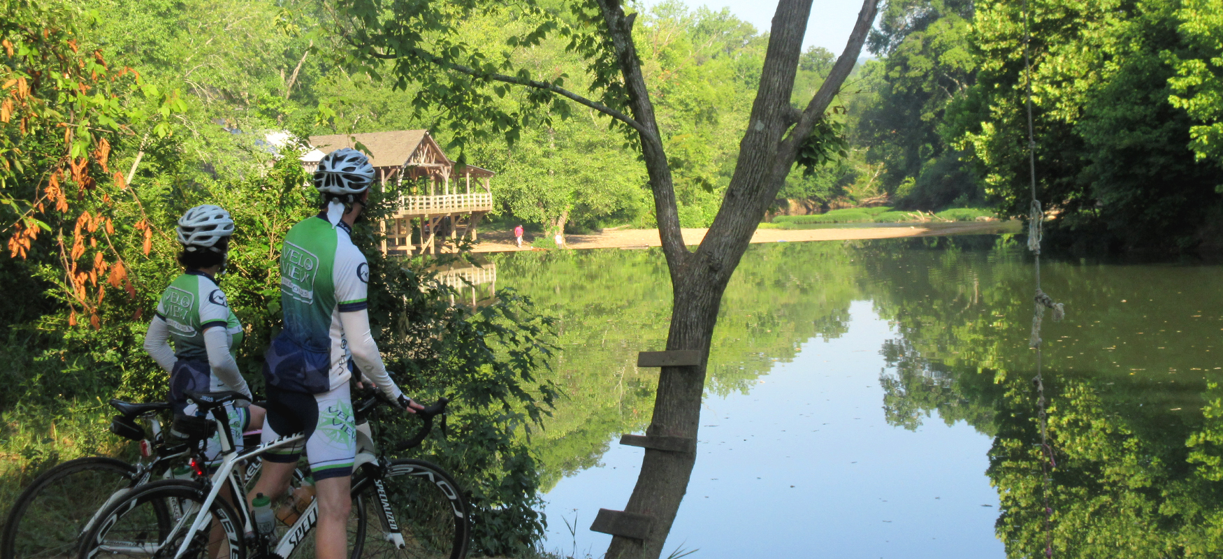
After checking out the farm, head back down Coppinger Cove Road to Valley View Highway and take a right. Less than half a mile later, turn right again onto Park Street just as you enter the little town of Sequatchie. Park Street does not have a street sign, but there is a marker for the Sequatchie Cave State Natural Area at this turn. Less than a quarter mile up Park Street you’ll see the cave and spring. Both are charming, but the main attraction here is the natural air conditioning immenating from the cave! Be sure to step down from the parking area and walk over towards the mouth of the cave. The drop in temperature is impressive - and refreshing!
After returning to Valley View Highway, it’s only three more miles to Jasper, where you’ll roll through the neighborhood streets back to Las Margaritas and a post-ride feast!