19 Miles / 1200 Feet of Climbing
See both sides of Signal Mountain, starting with a stunning view of the River Gorge and featuring a rolling ride along the edge of the eastern escarpment with panoramic views of Chattanooga and beyond!
Potential Route Modifications: The route can be shortened by close to 4 miles by turning around at the north end of Brow Road. (This also avoids a very steep hill!) You can also shorten the route by roughly 1 mile by opting to continue on North Palisades at mile 3.4 rather than doing the South Palisades loop. The route can also be made easier and shorter (by 3 miles) by starting on the east side of Hwy 127 (perhaps at the CVS) and skipping Signal Point Park altogether.
While there are a number of ways to explore Signal Mountain, we think the best way to experience it is to start at Signal Point Park. From the parking lot, it's a short walk down the hill to a stunning overlook, with the City of Chattanooga in the distance in one direction and the Tennessee River Gorge in the other. Beyond offering the view, Signal Point Park also has bathrooms. And if you need a shot of caffeine before you ride, Mayfly Coffee is just down the road.
After checking out the view, hop on the bike and head back the way you came, turning right onto James Avenue at the stop sign. Veer right as you head downhill onto Mississippi Avenue, which will take you all the way down to the stop sign at Signal Mountain Blvd. Go straight across Signal Mountain Blvd (use caution crossing this road), and follow Mississippi Avenue down to the traffic light at Hwy 127.
After going straight across Hwy 127 (MIssissippi Avenue will become Palisades Drive on the other side), take your first left, which is Ladder Trail. Ladder Trail climbs a short distance to a four-way stop. Go straight at the stop sign and follow Ladder Trail as it makes a steep descent before merging with Ravine Road. Veer left as the roads merge, and then take your first right to stay on Ravine Road.
Shortly after, take your first right onto Druid Drive which becomes Green Gorge Road. All of these right turns will have you riding along the edge of Green Gorge Park, which is a nice greenspace in the middle of the neighborhood. It's nice scenery and a fun stretch of road as it gently descends back down to Palisades Drive. (Don't get too carried away with the descent though, as it ends abruptly at a stop sign.)
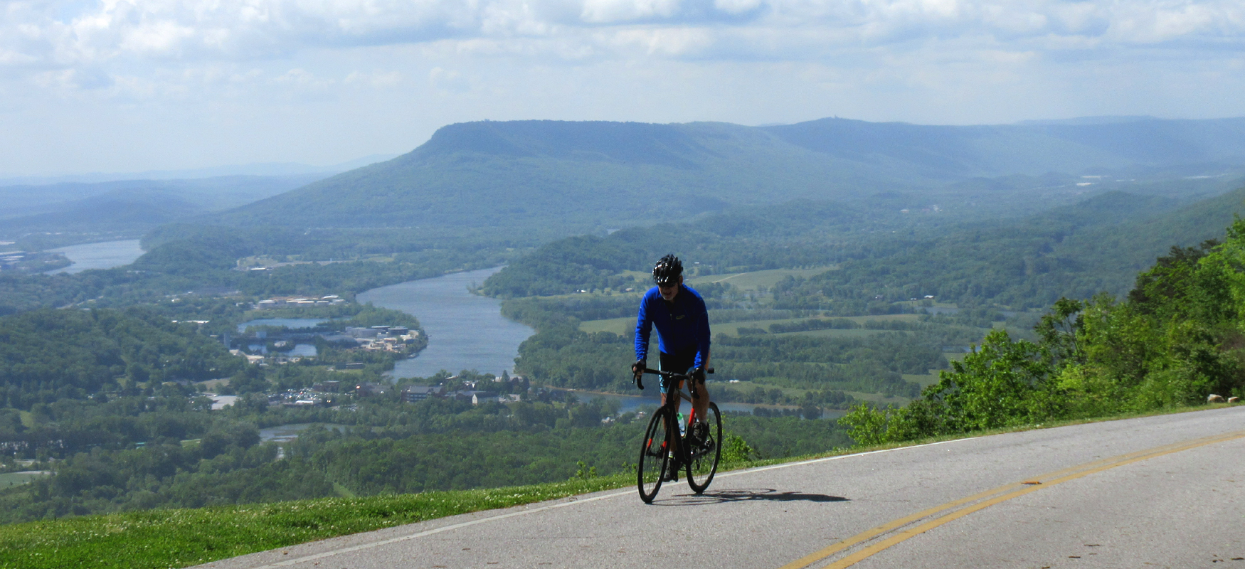
Take a left at the stop sign and head uphill on Palisades Drive. This is a sustained climb at a decent grade so gear down and find a steady rhythm. After a quarter-mile, Palisades Road will split into North Palisades and South Palisades. Veer right onto South Palisades and then take your first right to stay on South Palisades.
After turning right, the road drops down on a fast descent. It's a fun downhill but use caution on the curves. When the road bottoms out, it will bend sharply to the left and tilt up. The climb is about half a mile, so take your time. You can distract yourself from the grade by checking out the view between the houses. These spotty views are just a tease of what's in store for you later in the ride.
Following South Palisades will eventually bring you back to the intersection with North Palisades where you'll turn right and climb up to a fantastic view at a tiny park called Wilder Point. This spot is worth a stop to take in the view of Lookout Mountain, Chattanooga, Chickamauga Lake, and the Southern Blue Ridge Mountains in the distance.
This stop is just the beginning of the views, as North Palisades becomes more and more open the farther you go. In addition to the views, the road is a fun ride with plenty of curves and rollers! (Watch out for the curve at mile 5.4, as the road bends sharply to the right on a downhill.)
Eventually North Palisades comes to a stop sign as it intersects with the W Road. Go straight across this intersection onto Brow Road. Use caution here as cross-traffic does not stop and can be coming down the hill to your left pretty fast. And be sure not to go down the W Road. It's a steep curvy drop and you won't want to climb back up it! (The W Road gets its name from the series of switchbacks just below the stop sign.)
After crossing onto Brow Road, the views will open up even more as you ride along the escarpment. After a mile and a half of stunning views, the road dips down and turns to the left, becoming Lake Drive. Follow Lake Drive all the way down to a four-way stop.
Go straight at the stop sign onto Key-Hulse Road and gear down for a super steep climb. The grade on the first part of the climb is well into the teens and is a serious challenge. Fortunately, it's not that long and you'll be able to catch your breath before powering up the second part of the climb as it works it way up to Fairmount Pike.
At the top, take a right on Fairmount Pike and enjoy a well-deserved descent before turning right onto Olsen Avenue, about half a mile after making the turn. Keep an eye on the street names as there are several roads on the rightside of Fairmount Pike before you get to Olsen Avenue.
Olsen Avenue winds around about a mile before intersecting with Sawyer Road, where you'll turn right. After a brief uphill Sawyer Road starts to descend. Watch your speed rolling down Sawyer Road as it has a nasty left turn that comes without warning. Be prepared to turn 90 degrees to the left!
After navigating the corner, Sawyer Road comes to a "T" intersection with Wilson Avenue. Turn right onto Wilson Avenue and then take your first left onto Glenway Avenue. (Watch for this turn as it comes up quick on a little downhill.) Take your first right onto Ivory Avenue and you'll find yourself in a peaceful tree-covered neighborhood. (Be sure to look for the little "library" on the left soon after you turn onto Ivory.)
Ivory Avenue bends sharply to the left after a quarter-mile and you'll then turn right to stay on it. (Don't go straight at this intersection or you'll find yourself dropping down a long dead end!) After making the turn, Ivory comes to a stop sign at Lake Avenue. Cross traffic doesn't stop, so use caution as you take a left here.
After turning left, you'll climb your way back up to the Brow Road and begin retracing the route. (The views are worth riding it again!) As before, use extreme caution as you go across the intersection with the W Road, paying special attention to traffic coming downhill from the right.
On the other side of the W Road, you'll be back on Palisades Road, which you can follow all the way back to Hwy 127. (Be sure to stay left around mile 16 rather then veering off to the right.) Before you reach Hwy 127, you'll have a fast descent followed by a short steep stretch. Watch your speed on the descent as it curves to the left before bottoming out.
Once back at the stoplight at Hwy 127, you'll turn left onto the highway before immediately turning right onto Signal Mountain Blvd. This puts you on an uncomfortable stretch of road as you're heading uphill potentially in traffic. Fortunately this is a super short section, and you'll soon be taking a left to stay on Signal Mountain Road. This is a tricky intersection as Signal Mountain Road is your second left. Don't take your first left onto Mississippi Avenue. And use caution when turning, as oncoming traffic may be coming down the hill fast.
After making the turn onto Signal Mountain Blvd, you should have very little traffic as most vehicles use Mississippi Avenue instead. After a gradual half-mile climb, Signal Mountain Blvd merges with James Blvd and then intersects with Mississippi Avenue. Veer right to stay on James Blvd. Then take a left onto Signal Point Road, which will be your second left. Look for the sign pointing to Signal Point Park. From there it's an easy roll down to the park and that amazing view where you started.