43 Miles / 3000 Feet of Climbing
Take on a massive climb up Walden Ridge, ride across the farmland at the top, and then bomb back down to Dayton to celebrate at Monkey Town Brewing Company!
Potential Route Modifications: This loop can be ridden in either direction. We like going up the Evensville climb and coming down Brayton Mountain, which is how it's mapped, but you can reverse the direction if you would rather climb Brayton Mountain and come down Evensville.
There are two major climbs out of Dayton: Brayton Mountain and Evensville Mountain. Both are challenging, but Evensville gets the nod as the harder climb due to a steeper average grade. It's a great climb, and this route uses it as the way to get up onto Walden Ridge with Brayton Mountain as the way back down. That being said, this route can be reversed so that it climbs Brayton and descends Evensville. Since we already have a route that climbs Brayton Mountain (the Brayton Mountain Loop), we recommend taking the challenge of riding this route as we've mapped it.
Like the Brayton Mountain Loop, this ride starts & finishes at Monkey Town Brewing Company, which offers a wide variety of tasty craft beer along with an excellent lunch & dinner menu.
There's a free parking lot directly across from the brewery, and there's plenty of on-street parking as well. If you're up for checking out the shops on Market Street or the Scopes Trial Museum, you can also park in front of the Rhea County Courthouse, just a block away from the brewery. And of course there are a number of other great restaurants downtown as well!
You'll leave downtown heading north on 2nd Avenue, which will take you a half a mile before coming to a stop sign at Hwy 30. 2nd Avenue continues on the other side of Hwy 30, but you have to do a slight left/right jog to follow it.
After crossing Hwy 30, you'll be on rough pavement in a residential area before turning left a quarter-mile later onto Cemetery Road. Stay left on Cemetery Road as it passes by 11th Street and follow it down a fun little descent to Richland Creek. Watch your speed and watch the pavement on this section, as the road will still be rough as you're descending.
At the bottom of the descent, you'll come to a stop sign at Back Valley Road where you'll turn right. Back Valley Road is not a terribly busy road, but it may have a few cars, so listen for vehicles and stay to the right of the road.
About half a mile later, you'll see a sign for the Laurel-Snow State Natural Area on your left. Make a mental note of this location, as this is a place you should consider checking out later. It's a gorgeous park for hiking with great views, beautiful creeks, and a couple of stunning waterfalls!
Another half-mile and the road will bend sharply to the right. Don't follow that curve, as that is actually Walnut Grove Road. Instead, turn left, which will keep you on Back Valley Road.
This starts a nice section of roadway that has a good mix of wooded areas, small farms and rural scenery. It will last for almost four miles before you come to a stop sign. Turn left here to stay on Back Valley Road.
After such a nice ride on the previous section, the next mile will be noticeably less pleasant, with bumpier pavement and more traffic. It's not terrible, just not as nice. But it will all be over in less than a mile when you come to a four-way stop at the intersection with Evensville Mountain Road.
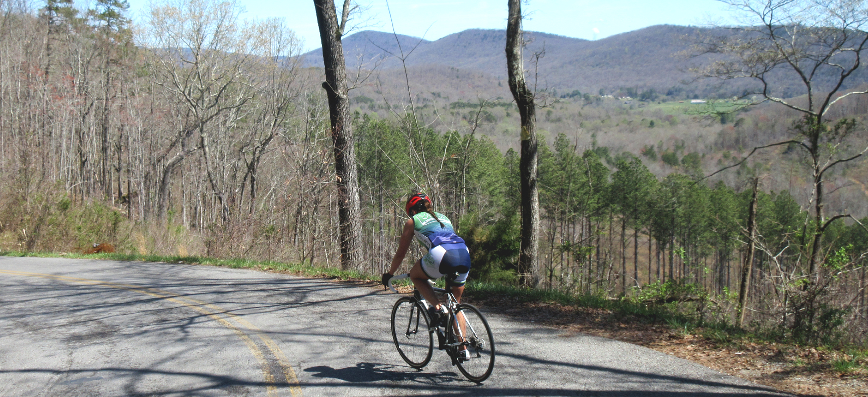
This is where the fun starts! Turn left, gear down, and settle in for a long climb and some significant suffering, as grades will rise into the teens as you make your way up this beast.
The first mile is the worst of it with sustained steep grades, but then it starts to ease up, and it will actually flatten out after a mile and a half. But don't be fooled. This is just one of a couple of false summits. The final push to the top starts a little after the two-mile mark, and you'll have a hard half-mile after that to crest the climb. When you get to the cell tower you'll know you're there! (In total, the climb is about three miles long.)
Stay to your left at the intersection with Wash Pelfrey Road as you reach the top, and the road will change names to Liberty Hill. This is a nice low-traffic rural road that will provide some relief after battling the climb, with a relatively flat stretch that lasts almost six miles. We say "relatively" because it has a rise in the middle that is definitely noticeable!
Liberty Hill Road will bring you to a stop sign at its intersection with Summer City Road. Take a left here and keep an eye out for traffic. While not a terribly busy road, it will have a few more cars than Liberty Hill and they may be going fast. So be aware of your surroundings and stay to the right.
After four and a half miles on Summer City Road you'll come to a stop sign at Hwy 30. Cautiously cross Hwy 30 and turn left when you reach the shoulder on the other side. Then immediately turn right onto New Harmony Road. (If you're hungry, there are two Mexican restaurants at this intersection. One of them is also a convenience store if you just need a snack and some drinks.)
The first two and a half miles on New Harmony Road are similar to Summer City in that you may have some traffic. But the farther you get from Hwy 30 the less cars you'll experience. The two and a half mile mark is also where you'll find Oren Wooden's Apple House, which is a fun stop in season. (Be sure to get a picture with the giant green chair!) There's also a restaurant directly across the street if you're looking for a full lunch.
After leaving the Apple House, the road should get quieter as you enter more open farmland. Less than 3 miles from Oren Wooden's Apple House is Phillip Wooden & Sons Farm Market, which is another great place to take a break. They have plenty of beverages on hand, and they also have a small restaurant if you want to take a lunch break (or just grab some cookies!). And of course they have a huge selection of seasonal produce.
Immediately after leaving the Farm Stand, you'll drop down a steep hill followed by a short climb. (Try to carry your momentum into that climb!) After this little roller coaster, you'll ride on moderate rollers for close to 7 miles as you follow New Harmony Road through more agricultural land with a smattering of rural houses in between farms. The road name will change to Brayton Mountain at some point along this stretch.
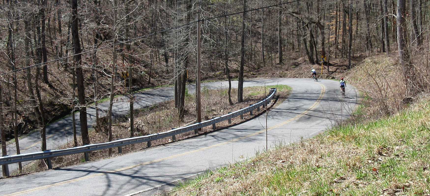
The rollers will end as you pass a chicken coop on the left and start to descend into more wooded terrain. The total descent is around 3.5 miles, with a few breaks in grade early in the descent. The road gets a little rough the farther you go, so keep your speed in check. Also be very careful at the pair of switchbacks you'll encounter about halfway down. This a steep section and you'll need to proceed around the curves slowly in order to stay in your lane.
Towards the bottom of the climb you'll get a nice view off to your right before the road dives back into the woods and then turns sharply to the right. This bend to the right signals the end of the fast part of the descent (and changes the road name from Brayton Mountain to Pikeville Avenue), but you can still get some speed pedaling the easy downhill after the curve. Just be sure not to fly past Long Street on your left at mile 37.3.
After turning left on Long Street, you'll continue downhill for another mile before coming to a stop sign at Cranmore Cove Road/303. Turn right here and then left at the stop sign you'll hit shortly after turning onto Cranmore Cove. This left will put you on Dayton Avenue, which you'll follow back to town for the next four miles.
Dayton Avenue changes names to Old Graysville Road along the way, and at the end of four miles of rollers, it will bend sharply to the right and change names again to Illinois Avenue. After following the righthand bend, take your first left onto California Avenue. There's a nice view of Lone Mountain off to your left on this stretch. Continue on California straight across Delaware Avenue and follow it across the train tracks down to the stop sign at Market Street.
Carefully take a left onto Market Street and then take your first right after crossing Richland Creek, which will be Alabama Avenue. Take your first left off of Alabama onto Church Street, which will run you down to First Street and Monkey Town Brewing Company, where good food and recovery beverages await!