56 Miles / 4000 Feet of Climbing
One of two Soddy Daisy routes that offer a great climb, fun descent, and the best way to ride north out of Chattanooga.
Potential Route Modifications: This route can be shortened considerably by moving the start/finish location north of Chattanooga to Red Bank, Falling Water or Soddy Daisy. Additional reductions can be made by turning left on Montlake Road at the Mountain General Store rather than continuing straight on Mowbray Pike (cutting off 8.5 miles) and by continuing straight on Montlake Road rather than turning left on Brow Lake Road (0.7 miles).
This route will not only take you to a great climb and one of the fastest descents in the region, but it will also introduce you to the best backroads to use when riding north of town. We've chosen Outdoor Chattanooga on Chattanooga's North Shore as our starting & finishing point, but the route can be joined at multiple locations to make the route shorter and easier.
A couple of notes before we get started:
- This is one of two routes that run between Chattanooga & Soddy Daisy. Both routes use the same roads to get to & from Soddy Daisy, but they offer different climbs once you get to Soddy. The other route uses the Hotwater climb and you can check it out by clicking here.
- We think the roads we've chosen to get to & from Soddy Daisy offer the best balance between climbing and avoiding traffic. There are of course alternatives. For a more direct but hillier approach to heading north out of Chattanooga, please see our Signal Mountain 2 route.
From Outdoor Chattanooga roll over to Tremont Street and follow it across Frazier Avenue and up the hill. (Be sure to check out iconic restaurant Aretha Frankensteins about half a mile up the hill. Their pancakes are ridiculously good!)
After a slow grind up the hill for just under a mile, you'll come to a four-way stop. Take a left here on Mississippi Avenue and ride the bike path to Dallas Road. At this traffic light, carefully take a right turn and head up the hill. This is a tricky little section because you'll need to slide into the left lane while pedaling slowly up a steep grade. Fortunately, it's a short section, and once you get in the left lane you'll be positioned to go straight onto Auburndale Avenue. Use caution as you cross onto Auburndale as cross-traffic does not stop.
Once on Auburndale, you'll be out of the traffic and can simply coast down the hill. Just watch your speed on the descent so that you can manage the left turn onto Oxford Road at the bottom of the hill. Almost immediately after turning left on Oxford Road, you'll turn right on White Oak Road and continue down the hill. White Oak becomes Memorial Drive as it veers to the left, and you may experience a few more cars as you approach Dayton Blvd.
At the stop light at Dayton Blvd, take a quick left-right jog onto California Avenue and gear down for a half-mile climb with some steep pitches. (The next few miles after crossing Dayton Blvd will have you on quiet neighborhood streets, so you shouldn't have any issues with traffic.) As you crest the climb, the road changes names to Sims Drive and winds around to a steep curvy descent. Use caution going down this hill, especially at the bottom when the road merges with Lullwater Road.
After the merge, take your first left onto Martin Road and follow it for almost a mile before taking a right turn onto Harwood Drive which will take you over to Lamar Avenue. (Any of the right-turn options off of Martin Road will get you to Lamar, but we prefer Harwood.)
Take a left on Lamar Avenue and follow it down a short hill to a four-way stop. Go straight through the four-way stop until you reach Morrison Springs Road. This is a tough intersection because you'll need to cross five lanes of traffic which can be busy during rush hour times. The key to safely crossing is to use the middle turn-lane. From the intersection with Lamar and Morrison Springs, take a right and slide into the middle turn-lane. Then take a left onto McCahill Road (about 1/10th of a mile from Lamar just past Hardees).
Take your first left off of McCahill Road onto Reads Lake Road and follow it to a really fun downhill that opens up into a flat section with a great view of Signal Mountain/Walden Ridge directly in front of you. (Watch out for the speed bumps on this descent!)
Reads Lake will bring you to a "T" intersection with Mountain Creek Road where you'll turn right. The next 2.5 miles on Mountain Creek Road trend uphill with a few small hills to tackle, but it's a quiet and really enjoyable stretch of road. Mountain Creek Road eventually goes under Hwy 27 and ends at a "T" intersection with Browntown Road.
Take a left onto Browntown Road and follow it a little over 2 miles before taking a left onto Old Dayton Pike. The first mile on Browntown involves a little climbing, but the last mile has some really fun rollers that you can take at speed!
Shortly after passing back under Hwy 27 on Old Dayton Pike, take a left on Pitts Road. Pitts may have a few cars on it, so stay to the right side of the road on this stretch. A mile after turning onto Pitts you'll take a hard right onto Levi Road and follow it another mile before coming to a stop sign at Roberts Mill Road. This section of Levi Road is another fun stretch that has a slight downhill grade and some sharp turns that make it feel like a crit course!
At the stop sign, turn left onto Robert Mills Road and then take your first right onto Jackson Road (past the Baptist church after crossing the creek). Jackson Road will make you do a little climbing, but it also has a nice mountain view off to your left. Just after cresting the climb, take a left onto Higgins Road which will cut you over to Selcer Road where you'll turn right.
Selcer Road will wind around and eventually dump you out at Dayton Pike. Dayton Pike is a busy road, but it does have a shoulder. So cross to the other side of the road and turn left using the shoulder to make your way to the traffic light at the intersection with Thrasher Pike. Take a right onto Thrasher and follow it almost a mile before turning left onto Frontage Road. This section may have a little traffic as you cross over Hwy 27 so look carefully before making the left onto Frontage Road.
Once you're on Frontage Road, you should have no traffic and you can relax and enjoy two miles of truly flat riding - a rare find in the Chattanooga region! Frontage Road ends at a "T" intersection with Harrison Lane. Take a right here and then move into the left lane to take a left at the traffic light where Harrison intersects with Daisy Dallas Road.
Daisy Dallas heads uphill at first and then bends sharply to the left. After it passes under Hwy 27, take your first left onto Kingsboro Street. (You'll see a sign pointing to the Trail of Tears route.) A block later, Kingsboro runs into Church Street where you'll turn left, followed by a quick right onto Burns Street. Follow Burns Street to its intersection with Dayton Pike.
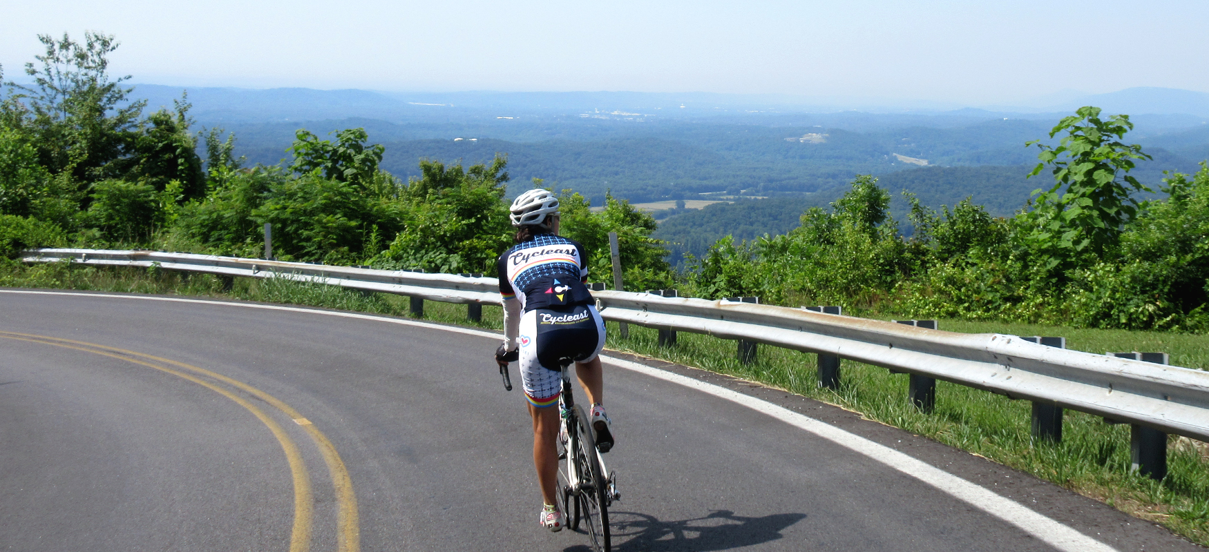
On the other side of Dayton Pike is Mountain Road, the start of the Mowbray climb. Carefully cross Dayton Pike and gear down on Mountain Road as you'll soon be working your way up double-digit grades. The initial shock of the steep grades will pass quickly though as the grade soon drops into a more manageable 6-10% for the majority of the climb, which changes names to Mowbray Pike along the way.
The climb is about 3 miles total (with a false summit about half a mile before the real finish), so settle into a steady rhythm and take your time. You'll know you're almost to the top when you see Hotwater Road off to your right. Stay left here or you'll end up rolling a long way down! (Hotwater is actually another great way to climb this mountain. Click here to see that route.)
Almost immediately after cresting the climb you'll see Mountain General Store on your left at the intersection of Mowbray Pike and Montlake Road. This is the perfect place to take a break and refuel after battling the climb. It's also an opportunity to assess how many miles you want to cover on this ride. You can skip the Mowbray Pike/Poe Road loop by turning left onto Montlake Road, which will cut off about 8.5 miles from the ride.
However, if you're feeling good, continue straight on Mowbray Pike for another 4.5 miles until it intersects with Poe Road. Turn left onto Poe Road and follow it 4 miles back to Montlake Road. This makes a nice loop with limited traffic and rolling terrain.
After turning right on Montlake, you'll roll up a gradual incline. Once you pass the water tower, the road will tilt downhill and you'll start to pick up speed. But don't go too fast since you'll want to turn left shortly after passing the water tower onto Brow Lake Road. (If you're more interested in shaving distance than seeing views, you can just continue straight on Montlake.)
Brow Lake Road starts off with a fun fast descent before bending sharply to the right and opening up to some nice views beyond the houses perched on the brow. After a few more curves and some up & down, Brow Lake Road will bring you back to Montlake Road where you'll turn left and launch into one of the best descents in the whole Chattanooga region!
With smooth pavement and manageable curves, the descent is fast and fun. The initial momentum is slowed by a slight uphill heading into a sharp righthand curve, but after that it really takes off! Just watch your speed towards the bottom as there is a sharp curve to the left that requires shedding some speed. Look for the yellow caution sign warning about this curve as you make your way down the mountain. After navigating the lefthand curve, the road straightens out and you can once again tuck in and fly!
This straightaway will eventually flatten out and you'll soon find yourself back at Dayton Pike. Turn right at this traffic light and ride the shoulder along Dayton Pike to the next traffic light, which is the intersection of Dayton Pike and Thrasher Pike. Watch the shoulder carefully on this section as it is usually full of gravel and trash. Unfortunately the shoulder gets even worse and pretty much disappears as you continue on Dayton Pike past the intersection with Thrasher. So just hold your line and keep pedaling until you reach Johnson Road, about a quarter-mile from the light.
Turn right onto Johnson, and then veer left to get onto Selcer Road. (This will feel more like going straight, as Johnson makes a hard right to a dead end.) Follow Selcer a mile and a half until you reach a "T" intersection with Roberts Mill Road. This a fun stretch of road with some great rollers and curves.
At the intersection with Roberts Mill, turn left and go half a mile until you see Levi Road on your right. Take this right and things should start to look familiar to you, although Levi Road won't feel quite as fast in this direction, as you'll have a slight uphill grade to contend with. Stay on Levi past its intersection with Pitts Road (which is the way you came) and onto a series of short climbs and descents that at this point in the ride will feel bigger than they are. Despite the extra burn in the legs, it's a nice road with little traffic and pleasant scenery.
After more than 3 miles, Levi will bring you back to Browntown Road where you'll turn right. (There's a little pond here with a nice view of Walden Ridge in the background.)
After two and a half curvy and rolling miles on Browntown start looking for McCahill Road. You'll want to turn right on McCahill but the street sign will actually be on the left side of the road. After making this right turn you'll have a long gradual uphill followed by a nice downhill, with good scenery (and typically some horses) off to the right.
McCahill will bring you back to Morrison Springs Road where you'll have to navigate the 5-lane crossing again. As before, turn right and slide into the turn-lane before taking a left onto Lamar Avenue just past the gas station.
Go straight on Lamar Avenue through the 4-way stop and then take a right onto Harwood Drive (which will come just after a super steep little ramp). Harwood Drive will take you over to Martin Road where you'll turn left.
At the next stop sign, turn right onto Sims Drive and then veer to the left to stay on Sims Drive which will go straight into a tough climb. The climb is only about a quarter-mile and soon you'll be dropping back down as the road changes names to California Avenue. Be careful on this descent as the road can be a little rough in places. It also comes to an abrupt stop at the bottom of the hill when it runs into Dayton Blvd.
Use the crosswalk button to get through this traffic light and take Memorial Drive past the cemetery until it veers off to the right and becomes Whiteoak Road. You may have a little traffic on Memorial Drive but it should disappear when it turns into Whiteoak.
After about half a mile of gradual climbing on Whiteoak, you'll turn left onto Oxford Road and then immediately turn right onto Auburndale Avenue. This is where the real climbing starts, as the grades quickly hit double digits. It's a short climb though, and once you make it to the top you'll be pretty much done with climbing for the day.
At the top of the climb you'll want to continue straight onto Dallas Drive. Use caution here though as Dallas can have some fast-moving traffic. Once on Dallas, slide into the left lane so that you can make a left turn onto Mississippi Avenue at the next traffic light.
After taking a left on Mississippi, ride the bike lane all the way to the four-way stop with Tremont Street. (There's a confusing intersection about a quarter-mile after turning onto Mississippi where the road bends to the left. Say to the left here rather than rolling straight, which would put you on Forest Avenue.)
At the four-way stop, turn right onto Tremont and roll all the way down the hill to the traffic light at Frazier Avenue. Go straight through the light and turn right to get back to Outdoor Chattanooga where you can dismount and refuel at one of the many great restaurants on Chattanooga's North Shore!