48 Miles / 4200 Feet of Climbing
This challenging ride has it all - arguably the hardest climb in the Chattanooga region, a fun fast descent, sections of quiet neighborhood roads, and incredible views!
Potential Route Modifications: This route can be shortened a number of ways by starting north of Chattanooga (somewhere in Red Bank). It can also be shortened by 9 miles by heading down the W Road the first time you come to it (mile 25) rather than continuing south to ride the Brow Road and see Signal Point Park. Taking in the Brow Road but skipping Signal Point Park (staying on the east side of Hwy 127) will shave off 3 miles from the route. Unfortunately, there's no way to avoid the climb up Robert's Mill Road on this route. If you don't want to do the climb or the descent down the W Road, please see the route for Signal Mountain 1.
This route has plenty of rewards - beautiful roads, big views, fun descents - but it's definitely one for the climbers! While there are many ways to shorten the route and make it somewhat less challenging (see the potential modifications above), there's no way to make it easy.
We should note, however, that there is an alternative route for heading north out of Chattanooga that has shallower grades. We've picked the most direct route to get in & out of town and it involves some steep hills. (We figure if you've opted for this route you're not averse to climbing!) But if you want hills that are not as steep, you can use the roads shown in our Soddy Daisy routes.
We've chosen Outdoor Chattanooga on Chattanooga's North Shore as our starting & finishing point, but the route can be joined at multiple locations to make the it shorter.
From Outdoor Chattanooga, roll over to Tremont Street and take it up to the traffic light at Frazier Avenue. Take a left on Frazier and ride in the right lane for a few blocks until you reach Woodland Avenue, where you'll turn right. After a quarter-mile on Woodland, veer to the left onto Hamilton Avenue and follow it down to Market Street. Turn right onto Market Street and ride in the bike path for another quarter-mile before sliding into the left-turn lane to cut over to Hamilton Avenue. Use caution as you come out of the bike lane to get over to the turn lane as traffic on Market Street can be fast.
Once you're safely across Market Street and on Hamilton Avenue, you'll have very little traffic to contend with as you ride through a residential area. Hamilton Avenue takes you uphill, starting gradually at first and then turning quite steep. The steep part is roughly half a mile, so gear down and take your time.
As you crest the climb and start to go downhill, look for White Oak Park on your left. This is your cue to take a left (onto Ben Miller Pkwy) and roll down the hill past the park. Ben Miller Pkwy becomes Midvale Avenue as the hill bottoms out and you enter a residential area. Look for Lyndon Avenue on your right and follow it over to Memorial Drive where you'll turn left and immediately hit the stoplight at Dayton Blvd.
At the stoplight at Dayton Blvd, take a quick left-right jog onto California Avenue and gear down for a half-mile climb with some steep pitches. (The next few miles after crossing Dayton Blvd will have you on quiet neighborhood streets, so you shouldn't have any issues with traffic.) As you crest the climb, the road changes names to Sims Drive and winds around to a steep curvy descent. Use caution going down this hill, especially at the bottom when the road merges with Lullwater Road.
After the merge, take your first left onto Martin Road and follow it for almost a mile before taking a right turn onto Harwood Drive which will take you over to Lamar Avenue. (Any of the right-turn options off of Martin Road will get you to Lamar, but we prefer Harwood.)
Take a left on Lamar Avenue and follow it down a short hill to a four-way stop. Go straight through the four-way stop until you reach Morrison Springs Road. This is a tough intersection because you'll need to cross five lanes of traffic which can be busy during rush hour times. The key to safely crossing is to use the middle turn-lane. From the intersection with Lamar and Morrison Springs, take a right and slide into the middle turn-lane. Then take a left onto McCahill Road (about 1/10th of a mile from Lamar just past Hardees).
Take your first left off of McCahill Road onto Reads Lake Road and follow it to a really fun downhill that opens up into a flat section with a great view of Signal Mountain/Walden Ridge directly in front of you. (Watch out for the speed bumps on this descent!)
Reads Lake will bring you to a "T" intersection with Mountain Creek Road where you'll turn right. The next 2.5 miles on Mountain Creek Road trend uphill with a few small hills to tackle, but it's a quiet and really enjoyable stretch of road. Mountain Creek Road eventually goes under Hwy 27 and ends at a "T" intersection with Browntown Road.
Take a left onto Browntown Road and follow it a little over a mile before taking a left onto Levi Road. (There's a small pond at this turn with a nice view of Walden Ridge in the background.) The first three miles of Levi Road has a lot of up & down, but after it bends to the left at mile 14.7 (do not go straight here!) it turns into a really fun stretch that has a slight downhill grade and some sharp turns that make it feel like a crit course!
After a mile, Levi ends at a "T" intersection with Roberts Mill Road. Take a left here, and less than a mile later, the road will turn straight up and you'll be on arguably the hardest climb in the entire Chattanooga region! The climb is only a mile and a half, but it's super steep with grades hovering around 20% in a few sections and little opportunity to catch your breath. The majority of cyclists who attempt the climb inevitably put a foot down at some point, so it is imperative to go as slow as possible to keep your heart rate out of the red zone.
Unfortunately, new residential development above Roberts Mill Road has added more cars to the road, so use caution when climbing and stay to the right side of the road (avoid weaving across the road as much as possible).
Roberts Mill becomes Sawyer Road as you reach the top and the grade starts to come down - along with your heart rate! Continue on Sawyer Road for the next 5.5 miles as it winds around through a large-lot residential area. Be sure to go straight past Corral Road, and be careful on the sharp lefthand bend in the road around mile 20.5. The curve is sharper than it appears at first and it's easy to carry too much speed as you head downhill. After the curve you can bomb the rest of the hill and try to carry some momentum into the subsequent climb (which is substantial at 3/4 of a mile).
One final note of caution about this stretch of Sawyer Road, As you near the end of Sawyer Road (around mile 22.6) there is a 90-degree lefthand bend that comes out of nowhere. It comes just as the road starts to go downhill after a long stretch of uphill, so it's easy to get excited about going fast again. However, you'll want to check your speed so that you don't hit the curve too hot!
Shortly after this curve, Sawyer ends at a "T" intersection with Wilson Avenue. Turn right onto Wilson Avenue and then take your first left onto Glenway Avenue. (Watch for this turn as it comes up quick on a little downhill.) Take your first right onto Ivory Avenue and you'll find yourself in a peaceful tree-covered neighborhood. (Be sure to look for the little "library" on the left soon after you turn onto Ivory.)
Ivory Avenue bends sharply to the left after a quarter-mile and you'll then turn right to stay on it. (Don't go straight at this intersection or you'll find yourself dropping down a long dead end!) After making the turn, Ivory comes to a stop sign at Lake Avenue. Cross traffic doesn't stop, so use caution as you take a left here.
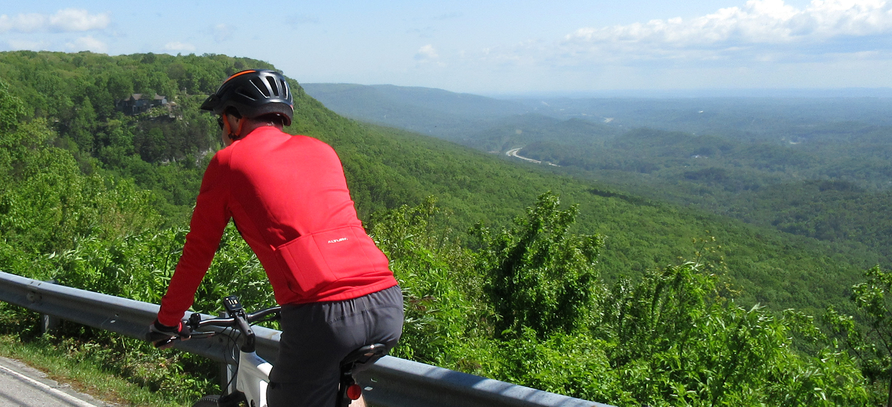
After turning left, you'll climb up to the Brow Road and be greeted with a wide-open panoramic view as you ride along the edge of the escarpment. After a little over a mile of this scenic section, you'll come to an intersection with the W Road.
If you feel like you may have bitten off more than you can chew with this ride, you can take a left onto the W Road and head down the mountain and begin the journey back to town. (That will shave off 9 miles from the ride.) But if you're feeling good and want to take in some more great views, continue straight across the W Road onto Palisades Drive. Use extreme caution as you go across this intersection, paying special attention to traffic coming downhill from the right.
On the other side of the W Road, you'll enjoy more views and some fun (and occasionally challenging) rollers as you work your way along the escarpment. Be sure to stay left around mile 27 rather then veering off to the right, and then be sure to veer right at mile 27.8 as you follow Palisades down a fast descent. Watch your speed on this descent as it curves to the left before bottoming out.
After going up a short climb, you'll find yourself at a stoplight at Hwy 127. Turn left onto the highway and then immediately turn right onto Signal Mountain Blvd. This puts you on an uncomfortable stretch of road as you're heading uphill potentially in traffic. Fortunately this is a super short section, and you'll soon be taking a left to stay on Signal Mountain Road. This is a tricky intersection as Signal Mountain Road is your second left. Don't take your first left onto Mississippi Avenue. And use caution when turning, as oncoming traffic may be coming down the hill fast.
After making the turn onto Signal Mountain Blvd, you should have very little traffic as most vehicles use Mississippi Avenue instead. After a gradual half-mile climb, Signal Mountain Blvd merges with James Blvd and then intersects with Mississippi Avenue. Veer right to stay on James Blvd. Then take a left onto Signal Point Road, which will be your second left. Look for the sign pointing to Signal Point Park.
From there it's an easy roll down to the park. At the park you'll find restrooms and an amazing overlook just down the hill from the parking lot. From the overlook you vcan see the City of Chattanooga in the distance in one direction and the Tennessee River Gorge in the other. It's definitely worth the stop!
After the photo op at the overlook, head back out the way you came, turning right onto James Avenue at the stop sign. Veer right onto Mississippi Avenue as you head downhill, which will take you all the way down to the stop sign at Signal Mountain Blvd. (Just before you reach the stop sign, you'll see Mayfly Coffee and Hummingbird Pastaria on the right side of the road. These are both excellent stops if you're looking for a shot of caffeine or a proper lunch.)
Go straight across Signal Mountain Blvd (use caution crossing this road), and follow Mississippi Avenue down to the traffic light at Hwy 127.
After going straight across Hwy 127 (MIssissippi Avenue will become Palisades Drive on the other side), take your first left, which is Ladder Trail. Ladder Trail climbs a short distance to a four-way stop. Go straight at the stop sign and follow Ladder Trail as it makes a steep descent before merging with Ravine Road. Veer left as the roads merge, and then take your first right to stay on Ravine Road.
Shortly after, take your first right onto Druid Drive and then a tenth of a mile later take a left to stay on Druid Drive. Druid will take you back up to Palisades where you'll turn left and once again get to enjoy the rollers and views riding along the escarpment.
After a couple of miles on Palisades, you'll come back to the intersection with the W Road. After carefully checking for traffic coming down the hill to your left, take a right and start the descent down the W Road. You'll immediately find yourself in a series of sharp switchbacks, which is the "W" part of the W Road. Be careful on this first part, as the road is narrow and vehicles tend to swing wide in order to make the corners.
After clearing the switchbacks, the road straightens out and turns into a really fun & fast descent. In total the descent is 3 miles of downhill joy, most of which is straight and easy. Pay attention to the warning signs towards the bottom of the climb though, as there are a couple of sharp corners as you bottom out.
The descent ends abruptly at a traffic circle where the W Road intersects Mountain Creek Road. Use the round-about to turn left onto Mountain Creek. The next couple of miles are a little unpleasant as you'll most likely have to deal with some traffic. Just hold your line and stay to the right. You'll also have another traffic circle to contend with (continue straight through it), and you'll have a tricky intersection with Morrison Springs Road at mile 39.4. To continue on Mountain Creek past Morrison Springs, you'll need to slide onto the left lane, as the right land becomes a right-turn only. Be careful crossing Morrison Springs as cross traffic does not stop.
Once you get on the other side of Morrison Springs, the traffic should diminish and it will be easy going as you approach Reads Lake Road. Take a right on Reads Lake and things should start to look familiar as you retrace your route back to the start. Of course, the fun descent down Reads Lake will now be a tough climb!
After making your way up the climb, follow Reads Lake to its intersection with McCahill Road where you'll turn right. Almost immediately after making this turn, you'll be back at Morrison Springs Road where you'll have to navigate the 5-lane crossing again. As before, turn right and slide into the turn-lane before taking a left onto Lamar Avenue just past the gas station.
Go straight on Lamar Avenue through the 4-way stop and then take a right onto Harwood Drive (which will come just after a super steep little ramp). Harwood Drive will take you over to Martin Road where you'll turn left.
At the next stop sign, turn right onto Sims Drive and then veer to the left to stay on Sims Drive which will go straight into a tough climb. The climb is only about a quarter-mile and soon you'll be dropping back down as the road changes names to California Avenue. Be careful on this descent as the road can be a little rough in places. It also comes to an abrupt stop at the bottom of the hill when it runs into Dayton Blvd.
Use the crosswalk button to get through this traffic light and take Memorial Drive a short block before turning right onto Lyndon Avenue. Follow Lyndon a half-mile until you reach a stop sign. Take a left here onto Midvale Avenue and follow it uphill as it becomes Ben Miller Parkway and takes you past White Oak Park.
The steep climb continues a short distance more as you turn right onto Pine Breeze Road before finally cresting and dropping down into a residential area (and changing names back to Hamilton Avenue). At the intersection with Dallas Road turn right into the bike lane and follow it half a mile before taking a left on Bush Road (just before you get to the Publix grocery store). Use caution taking this left, as traffic can be heavy around the grocery store.
Immediately after making the turn, veer right onto Hamilton Avenue and then veer right again at the intersection with Woodland Avenue. Woodland will take you down to a traffic signal at Frazier Avenue where you'll turn left. Stay in the right lane and follow Frazier a quarter-mile to a traffic signal at Tremont Street. Take a right onto Tremont Avenue, followed by another right, which will have you back at Outdoor Chattanooga where you can take a deep breath and enjoy a proper recovery at one of the many great restaurants on Chattanooga's North Shore!