49 Miles / 2800 Feet of Climbing
Ride straight from downtown Athens into the beautiful East Tennessee countryside on this hilly survey of the Scenic South!
Potential Route Modifications: This route can be shortened to 38 miles by veering to the left at mile 14 and taking County Roads 59 to 38 to 51, which will bring you south to Co Rd 50, where you'll pick up the regular route.
We recommend starting the ride from downtown Athens, which has a free visitor parking lot near the county courthouse (an impressive building!) along with clean restrooms. This makes for a great place to start, and it also puts you in easy walking distance from several restaurants where you can refuel after the ride. (Another option for post-ride recovery is Jenkins Grille & Market less than a mile away on Jackson Street.)
Vehicles move slowly in downtown Athens, so rolling out from the downtown parking lot should be no problem even if there is traffic. Just mind the one-way streets as you work your way to Hill Street and up to Wabash Street. Take a left on Wabash Street and you’ll get a steep but short warm-up climb up to Harper Johnson Drive, where you’ll turn right and proceed to Cook Drive. Use caution as you take a left onto Cook Drive and then take your first right across the railroad tracks.
Immediately after crossing the tracks, turn left onto Tell Street, which is a narrow one-way street that parallels the train tracks and runs you over to Frye street where you’ll turn right and immediately head straight up a hill (bending around to the left). Frye Street becomes Maple Street as it bends to the right and comes to a “T” intersection with Old Riceville Road.
Turn left and follow Old Riceville Road almost all the way to the train tracks, turning right onto Rocky Mt Road just after the convenience store. Use caution on this road and ride single-file if you’re in a group, as it may have some traffic. A mile later, you’ll come to a traffic signal at Congress Parkway (also known as Hwy 11). Take a left at the intersection but make sure you’re in the right lane as you move through the intersection because you’ll want to hop on the shoulder as you turn onto Hwy 11 and then immediately turn right to continue on Rocky Mt Road. As before, be aware of passing vehicles on this stretch of road.
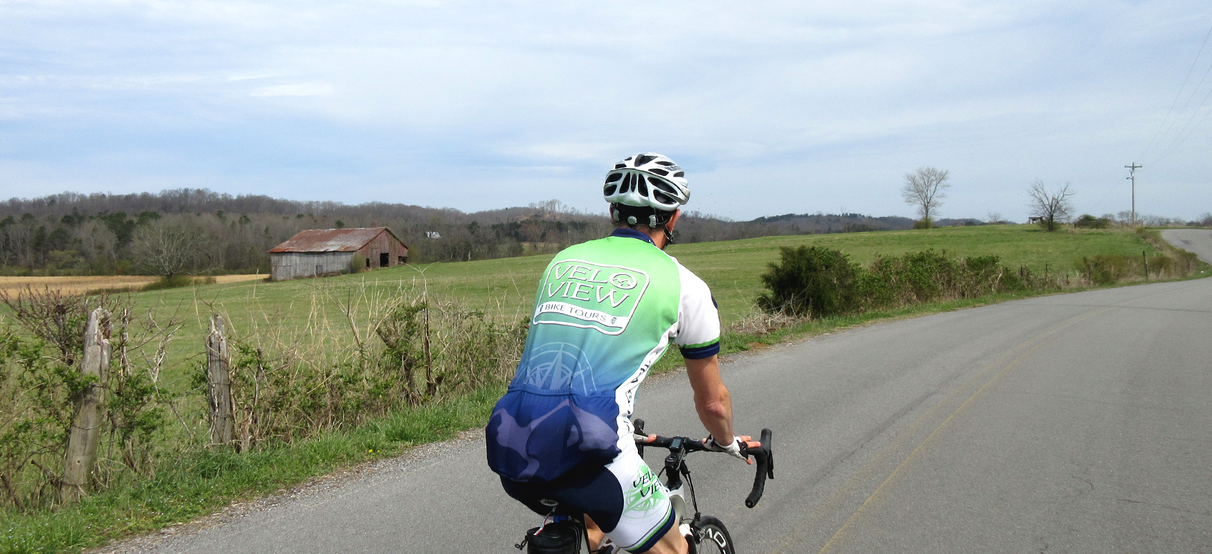
After another mile, you’ll turn left onto Co Rd 131, which will feel very different than the city streets you’ve been riding. Not only will you notice a lack of traffic, but you’ll also immediately find yourself riding in a rural setting. You’ll also notice that the pavement is a lot bumpier and you may encounter some loose dogs. (Try sweet-talking them first. If that doesn’t work, give them a stern “No!” And if that doesn’t work, spray them in the nose with your water bottle.)
Another interesting characteristic of rural backroads in this part of country is the diversity of housing - some traditional farm houses, some newer homes, and some residences that have fallen into disrepair. It’s a wide diversity and creates a sometimes-striking contrast between the beautiful natural setting and the poorly maintained manufactured one. This is the reality of the rural South, and we recommend focusing on the beautiful parts and looking the other way when passing by the less attractive additions to the landscape.
After a mile and a half, Co Rd 131 will bring you to a “T” intersection with Co Rd 114, where you’ll turn right followed by a left on Co Rd 116 less than half a mile later. As you make the turn onto Co Rd 116, look to your left for Cate Spring, which forms a beautiful pond before flowing under Co Rd 116. It’s definitely worth slowing down for.
Another interesting water feature to look for is Blue Cove, which is about a mile down Co Rd 116 on your right side. The former rock quarry was once a popular swimming hole but was closed in 2018 for health reasons. While you can’t go in, you can still get a good look at it from the road (which runs along a bluff overlooking the pond).
Continue on Co Rd 116 for another 3 miles past Blue Cove (passing under I-75 along the way) until you see Co Rd 115 on your right (at mile 10.4). After you turn, you’ll make a slow climb up Co Rd 115 before dropping down a steep descent which unfortunately ends abruptly at a stop sign (so watch your speed coming down!).
Take a left onto Co Rd 110 at the stop sign and follow it half a mile to Riceville-Decatur Road/Co Rd 100, where you’ll take a right. Riceville-Decatur Road may have some fast-moving traffic. You’ll only be on it for half a mile but be aware of passing vehicles. Take the first left you come to, which is Brush Creek Road/Co Rd 82. (Be advised that this road passes by an elementary school which may generate a little traffic when kids are being dropped off and picked up. Also, make sure you stay to the right at mile 14 rather than veering left onto Co Rd 59.)
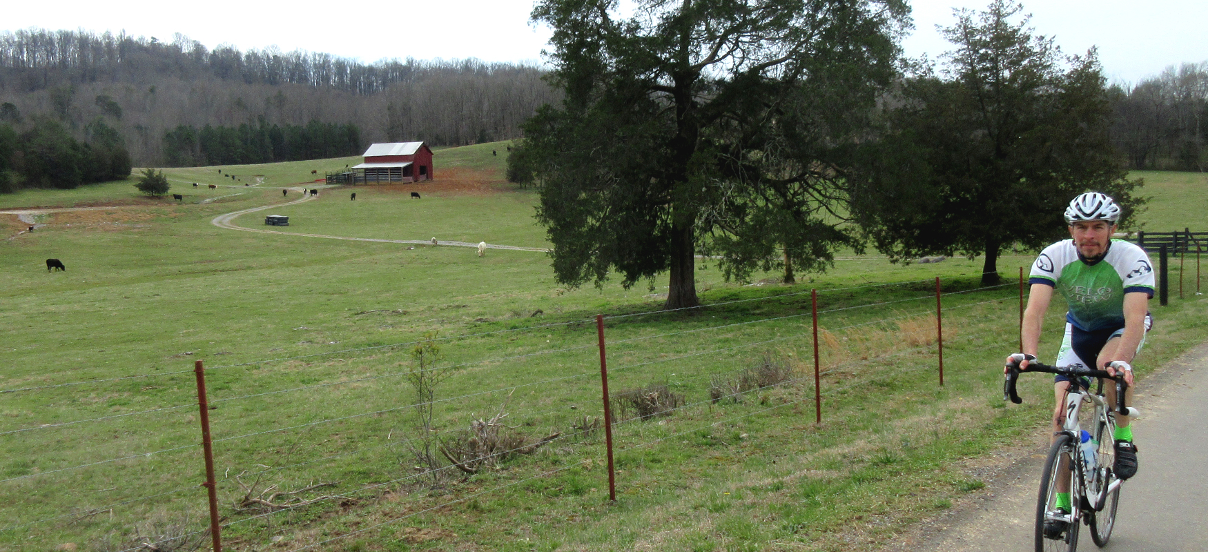
After a little over 3 miles, take a left off of Brush Creek Road onto Co Rd 52, which will put you on a short climb followed by a nice descent. Co Rd 52 “T’s” into Co Rd 51, where you’ll turn right and follow Short Creek through a nice wooded section before opening up into farmland as you come to the intersection with Co Rd 50. Turn left on Co Rd 50 and climb up past a large farm. Stay along the perimeter of the farm by turning right onto Front Buckhorn Road/Co Rd 48. Less than a mile later, Front Buckhorn Road takes a sharp left. (If you veer to the right you’ll end up on Co Rd 46 which will have you heading in the wrong direction!)
Once you make this turn, you’ll be on Front Buckhorn Road for the next four and a half miles, most of which is a pleasant tree-lined downhill ride! The road bottoms out at a “T” intersection with Lamontville Road/Co Rd 20, where you’ll take a left. Lamontville Road has the potential to have fast-moving traffic, so use caution as you pull out onto the road. Fortunately you’ll only be on Lamontville Road for less than half a mile before taking a left onto Shelton Road/Co Rd 4.
Shelton Road will gradually head uphill (becoming a little steeper the farther you go!) and offers some beautiful wide-open vistas. It finished with a short steep downhill that bottoms out at a “T” intersection with Matlock Road/Co Rd 50. After turning right onto Matlock Road, you’ll start a one-mile climb with steady grades around 6% (steeper towards the top).
After cresting the climb, you’ll enjoy a nice descent that will drop you off at the bottom of yet another tough hill, this one just under a mile with similar grades. The descent following the climb will take you back under I-75 and drop you down past a large farm operation before gradually heading back uphill to Hwy 11, where you’ll go straight across. The traffic will be fast on Hwy 11, so use caution going across. And also be careful crossing the train tracks on the other side of the road.
After crossing Hwy 11 you’ll veer to the right and launch onto a pretty challenging half-mile climb that will reward you with a sweeping view of the countryside, including the Southern Blue Ridge mountains and the Cherokee National Park in the distance. The descent is a lot of fun, but use caution as the road surface is a little rough and curvy. The road (now named Co Rd 730) bottoms out at an old bridge and large abandoned brick building next to the Hiwassee River.
After crossing the bridge, take a left on Eastanallee Valley Road/Co Rd 740 through some gorgeous farmland scenery. (Please note that Eastanallee Valley Road turns sharply to the right after a couple of miles. Don’t proceed straight onto Co Rd 726!) After three beautiful miles, you’ll come to a “T” intersection with Cedar Springs Road/Co Rd 700. Compared to the farm roads you were just on, Cedar Springs Road will have more traffic at higher speeds, so ride single file and be aware of passing vehicles.
A little under 2 miles after turning onto Cedar Springs Road, you’ll turn left on Hub Dodson Road/Co Rd 752 and follow it for another 2 miles until you come to a “T” intersection with Long Hollow Road/Co Rd 655. Turn right on Long Hollow Road and then shortly after turn left on Clayhill Road/Co Rd 675, which will give you almost 3 miles of short punchy hills.
Right before you get to mile 49, take a right on Larry Ellis Road/Co Rd 669. This road may not have a street sign, so watch your odometer so that you don’t miss it! Larry Ellis Road is a nice wooded road that will give you a pleasant downhill before turning up to bring you to Underdown Road/Co Rd 668 on the right. Underdown Road is also easy to miss, so again watch your odometer. It comes a little after mile 45.
As the name indicates, Underdown Road takes you down, which is nice until it pops back up with a steep hill towards the end of this half-mile road. At the top of the hill you’ll come to a “T” intersection with Long Mill Road/Co Rd 658. Take a left here and watch your brakes as you drop down a super steep descent. It’s short but fast!
After the initial descent, Long Mill Road turns into a series of ups & downs over the course of the next 2 miles. Long Mill Road will bring you to Cedar Springs Road, where you’ll turn right and follow it straight into downtown and your starting point, which is less than a mile away!